
Thousands of visitors travel to Alta each summer to enjoy the stunning mountain scenery. Vehicle access into Albion Basin is limited to balance visitor use of the available amenities with the protection of natural resources as the ultimate goal.
Updated 6/30/2026 @ 9am
The Albion Basin Summer Road is open to vehicles.
Alta charges an amenity fee for vehicle use of the Summer Road that accesses the Cecret Lake and Catherine’s Pass trailheads. This money helps fund maintenance of the Summer Road, parking lots, trash removal, hiking trails and maintenance to bathroom facilities on-mountain.
Remember to stay on designated trails only. Avoid muddy trails and refrain from creating new ones around snow and mud. Weather in the mountains is always changing—view Alta's Mountain Cams and check the Weather Forecast >
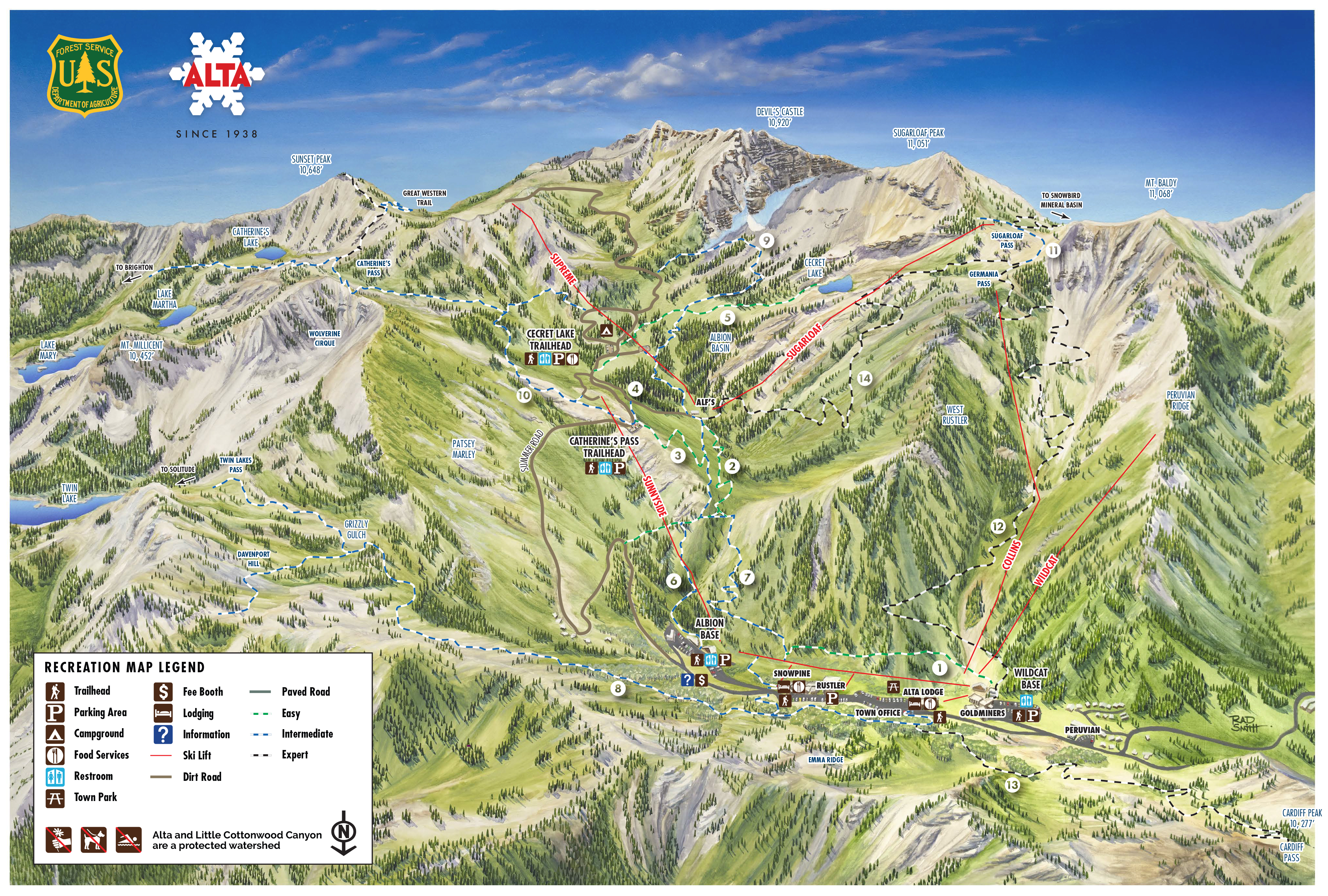
Trail Info
Easy
#1: Lower Albion Meadows | .5 miles | Elevation Gain: 100 feet
Current Conditions: Clear
A family-friendly trail connecting Wildcat and Albion base areas. You’ll find interpretive signs highlighting Alta’s history, geology, natural resources and watershed. An inviting stroll for wildflower viewers. Hiking/biking singletrack.
#2: Home Run | .6 miles | Elevation Gain: 200 feet
Current Conditions: Clear
Connect from the Albion base area to the Upper Albion Meadows trail. Recommended route for mountain biking. Hiking/biking singletrack.
#3: Albion Meadow | .5 miles | Elevation Gain: 70 feet
Current Conditions: Clear
Provides some of the best wildflower viewing in Alta. Please stay on the trail and use the photo pullouts for wildflower photography. Access from Catherine’s Pass Trailhead via the Summer Road or the Upper Albion Meadows trail from the Albion base area. Hiking/biking singletrack.
#4: Catherine's to Cecret Lake Connector | .29 miles | Elevation Gain: 40 feet
Current Conditions: Clear
A rolling hike in the meadows connecting the Cecret Lake and Catherine’s Pass Trailheads. Hiking/biking singletrack.
#5: Cecret Lake | .75 miles | Elevation Gain: 420 feet
Current Conditions: Clear
This very popular, easy-to-moderate trail features interpretive signs along a route to the spectacular Cecret Lake. Access from the Upper Albion Meadows trail or the Cecret Lake Trailhead via the Summer Road. Swimming or wading in the water is prohibited. Bikes are not allowed. Hiking singletrack.
Intermediate
#6: Upper Albion Meadows | 1.4 miles | Elevation Gain: 1,100 feet
Current Conditions: Clear
Starting from the Albion base area, a moderate climb leads to breathtaking views and fields of wildflowers. One of the best ways to access the Albion Meadows. Hiking/biking singletrack.
#7: Snake Pit | .7 miles | Elevation Gain: 365 feet
Current Conditions: Clear
This trail snakes through aspen groves before traversing a steep ravine into the Albion Basin. Enjoy views of a cascading creek. Hiking/biking singletrack.
#8: Twin Lakes Pass | 1.8 miles | Elevation Gain: 1,350 feet
Current Conditions: Clear
This moderate-to-steep trail climbs through Grizzly Gulch before connecting to Big Cottonwood Canyon at Twin Lakes Pass. This trail also offers a spur route to Davenport Hill. Access starts on the north side of Highway 210 across from the Snowpine Lodge. Hiking/biking singletrack.
#9: Devil's Castle Loop | 1.8 miles | Elevation Gain: 460 feet
Current Conditions: Snow and mud
Access this loop from the campground loop road or the Upper Albion Meadows trail just below the Cecret Lake trailhead. This is a popular mountain biking trail beneath the massive walls of Devil’s Castle. Hiking/biking singletrack.
#10: Catherine's Pass | 1.5 miles | Elevation Gain: 800 feet
Current Conditions: Clear
This moderate trail weaves through open meadows and wetlands leading to Catherine’s Pass with great views of Catherine’s Lake and Sunset Peak in Big Cottonwood Canyon. Hiking/biking singletrack.
#11: East Baldy Traverse (EBT) | .4 miles | Elevation Gain: 100 feet
Current Conditions: Clear
Begins at the merge of Collins Gulch and East Greeley, connecting Germania Pass to Sugarloaf Pass. Views of Mineral Basin and Mount Timpanogos. Hiking/biking doubletrack.
Expert
#12: Collins Gulch | 2.6 miles | Elevation Gain: 2,000 feet
Current Conditions: Clear
This moderate-to-steep service road climbs from the Wildcat base area to Germania Pass with great views of Mount Baldy. Connect to East Greeley in the Albion Basin or the East Baldy Traverse to Sugarloaf Pass. Hiking/biking doubletrack.
#13: Cardiff Pass | 1.4 miles | Elevation Gain: 1,360 feet
Current Conditions: Clear
This steep hike climbs to the ridgeline opposite Alta Ski Area, providing panoramic views of Alta. Access from the north side of Highway 210, across from the Alta Lodge, near the Town Office. Hiking/biking singletrack.
#14: East Greeley | 2.8 miles | Elevation Gain: 1,300 feet
Current Conditions: Clear
Gain access via the Upper Albion Meadows trail near Alf’s. This moderate-to-steep service road switchbacks through a quiet mountainside with panoramic views of Albion Basin. Connect to Collins Gulch or Sugarloaf Pass via the East Baldy Traverse Hiking/biking doubletrack.