Alta has transformed the great outdoors into our classroom with ten interpretive signs hidden throughout the slopes of Sunnyside. Each sign reveals fascinating facts about Alta’s ecology, geology, wildlife, history and more! SKE-COLOGY is a self-guided scavenger hunt that allows you to explore Alta while discovering what makes the mountain unique. This program began in the 1990s as a collaboration between the U.S. Forest Service, Vail Mountain Resort and Alta Ski Area and was initially designed for ski school groups and beginner skiers. Over the years, it has evolved into a year-round educational experience for skiers and hikers of all ages and skill levels.
Grab some popcorn and take a front-row seat for a SKE-COLOGY adventure with Ella and Juni
To join this adventure, follow the map to search for the signs and turn your day outside into a hands-on learning experience—whether you are skiing in the winter or hiking in the summer.
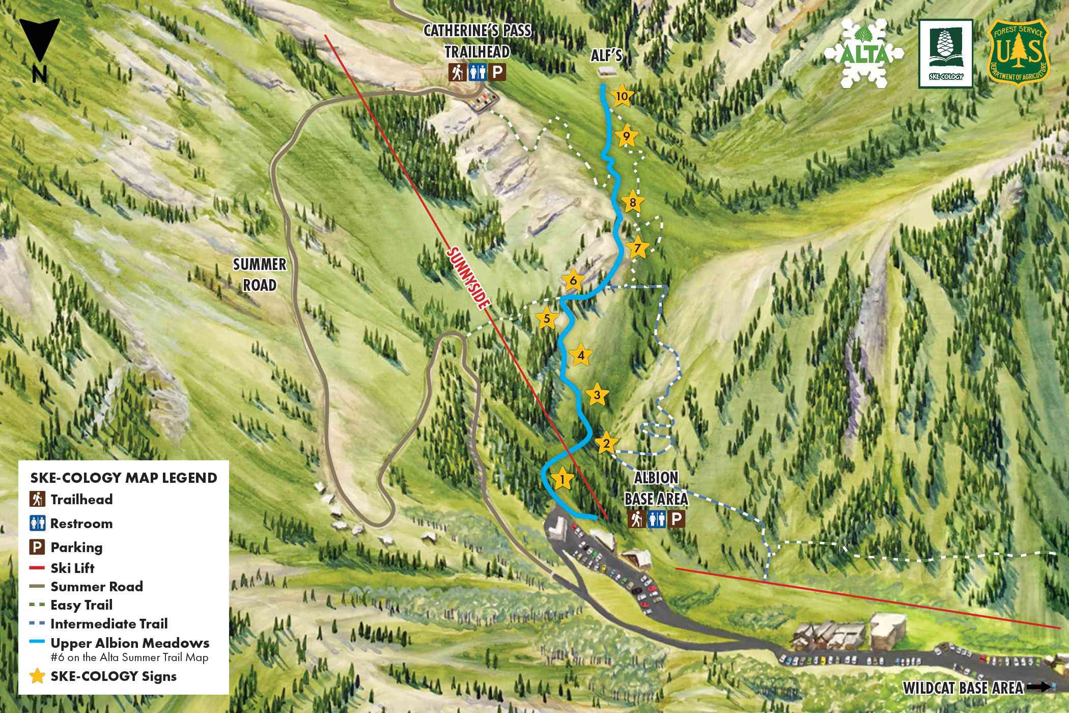
Summer Map
The fun and learning on the slopes is a year-round ordeal at Alta. Join the SKE-COLOGY scavenger hunt to find all ten interpretive signs and discover Alta’s wildlife, ecology, geology and history.
How to Explore
- Follow the SKE-COLOGY route along Upper Albion Meadows (#6 on the summer trail map). This 1.4-mile out-and-back trail climbs 1,100 feet and is best suited for intermediate hikers
- Use the map to guide your adventure from any starting point—whether you’re beginning at the base, Alf’s or somewhere in between.
- Check off each sign you find along the way.
- Read the signs to learn something new and answer the thinking questions.
- Explore with care—look only with your eyes and stay on designated trails to help protect this special place.
Map Coordinates
If you have a GPS device, enter the following coordinates to find the hidden SKE-COLOGY signs throughout Sunnyside.
- 40.58868° N, -111.62591° W
- 40.58807° N, -111.62540° W
- 40.58722° N, -111.62463° W
- 40.58674° N, -111.62416° W
- 40.58611° N, -111.62360° W
- 40.58580° N, -111.62351° W
- 40.58547° N, -111.624241° W
- 40.58412° N, -111.62369° W
- 40.58149° N, -111.62147° W
- 40.58033° N, -111.62067° W
Coordinates are subject to change. Signs may be located within a 15-foot radius of the provided location.
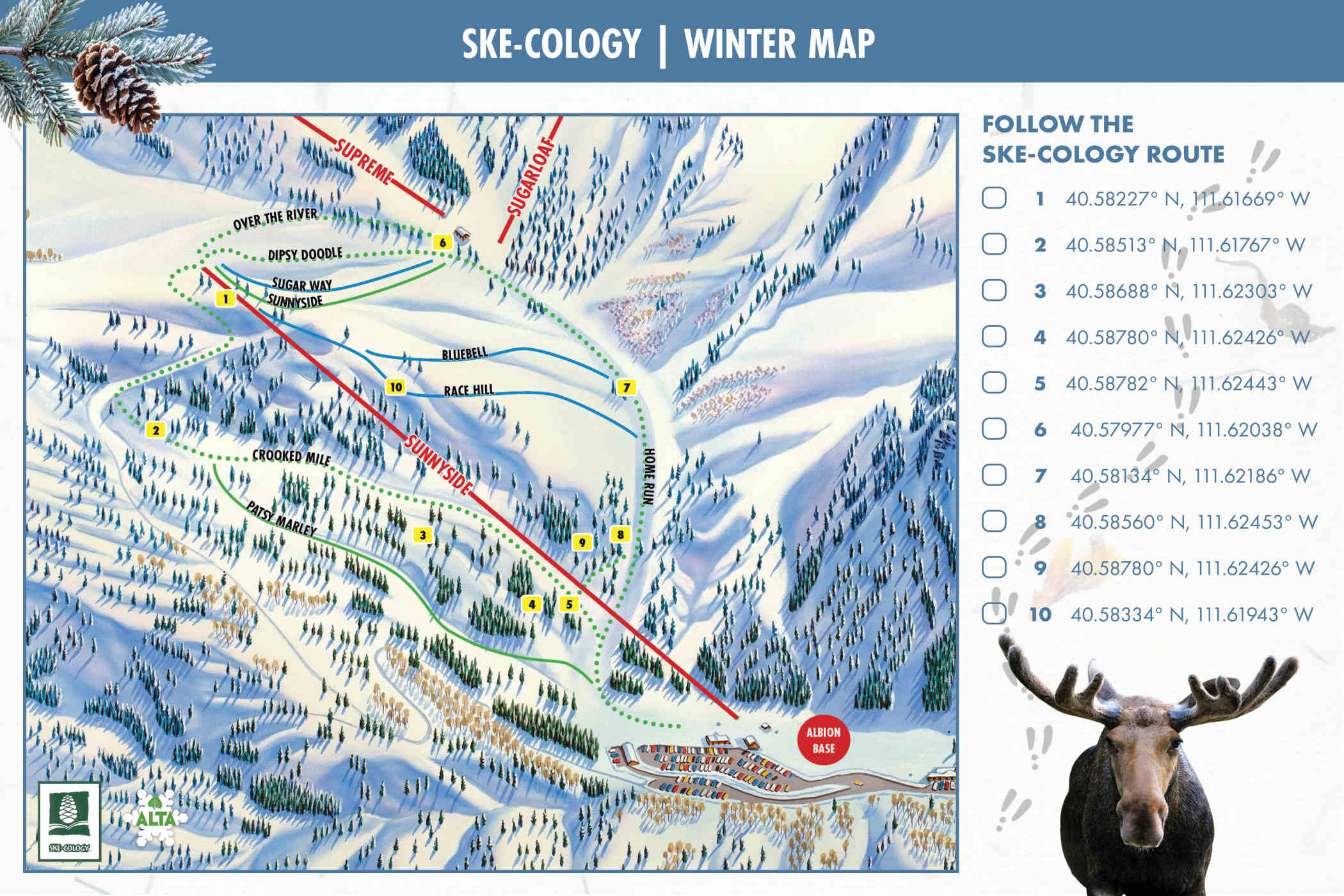
Winter Map
Want to add a little adventure to your day on the mountain?
- Grab your SKE-COLOGY map and start at the top of the Sunnyside lift
- Begin your search for all 10 hidden interpretive signs
- Read each sign and challenge yourself to answer the questions provided
- Check off each sign you find along the way to track your progress
Have fun, ski in control and follow the trail map as you explore Alta.
Map Coordinates
If you have a GPS device, enter the following coordinates to find the hidden SKE-COLOGY signs throughout Sunnyside. The signs are located within a 15-foot radius of the provided coordinates.
- 40.58227° N, 111.61669° W
- 40.58513° N, 111.61767° W
- 40.58688° N, 111.62303° W
- 40.58780° N, 111.62426° W
- 40.58782° N, 111.62443° W
- 40.57977° N, 111.62038° W
- 40.58134° N, 111.62186° W
- 40.58560° N, 111.62453° W
- 40.58780° N, 111.62426° W
- 140.58334° N, 111.61943° W
*Coordinates are subject to change
SKE-COLOGY K-12 UTAH EDUCATOR'S HANDBOOK
With the trademarked SKE-COLOGY program, we’ve revamped the content to focus more specifically on Alta’s unique ecology. While preserving the original program’s vision, we’ve designed the updated version to be easily adapted by ski areas and parks nationwide. This allows the program to highlight the local wildlife and ecosystems of any region while maintaining its core themes of watersheds, recreational etiquette, conservation and more!